


New Hope Voting District, Pike County, Arkansas
About
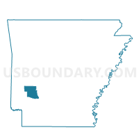
Outline

Summary
| Unique Area Identifier | 527628 |
| Name | New Hope Voting District |
| County | Pike County |
| State | Arkansas |
| Area (square miles) | 32.98 |
| Land Area (square miles) | 32.78 |
| Water Area (square miles) | 0.21 |
| % of Land Area | 99.38 |
| % of Water Area | 0.62 |
| Latitude of the Internal Point | 34.22225800 |
| Longtitude of the Internal Point | -93.87739630 |
Maps


Graphs
Select a template below for downloading or customizing gragh for New Hope Voting District, Pike County, Arkansas


Neighbors
Neighoring Voting District (by Name) Neighboring Voting District on the Map
- CLAY Voting District, Howard County, AR
- Daisy Voting District, Pike County, AR
- HOLLY CREEK Voting District, Howard County, AR
- Langley/Lodi Voting District, Pike County, AR
- MUDDY FORK Voting District, Howard County, AR
- Murfreesboro West 1 Voting District, Pike County, AR
Top 10 Neighboring County Subdivision (by Population) Neighboring County Subdivision on the Map
- Self Creek township, Pike County, AR (685)
- White township, Pike County, AR (618)
- Muddy Fork township, Pike County, AR (249)
- Mountain township, Pike County, AR (249)
- Holly Creek township, Howard County, AR (219)
- Clay township, Howard County, AR (155)
- Muddy Fork township, Howard County, AR (132)
Top 10 Neighboring Unified School District (by Population) Neighboring Unified School District on the Map
- Nashville School District, AR (9,494)
- Wickes School District, AR (3,273)
- Murfreesboro School District, AR (3,183)
- Dierks School District, AR (2,915)
- Kirby School District, AR (2,910)